Last Updated: October 18, 2026
Last Updated: October 18, 2026





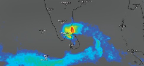
Cyclone Ditwah formed over the southwest Bay of Bengal on November 27, 2025, becoming the fourth tropical cyclone of the ongoing North Indian Ocean season. The system intensified quickly as it moved along favourable atmospheric and oceanic conditions near the Sri Lankan coast.
According to the India Meteorological Department, the disturbance strengthened from a depression into a deep depression during the early hours of November 27. By 11:30 am, it had intensified into a cyclonic storm, displaying early signs of rapid strengthening. The IMD placed the system over the southwest Bay of Bengal and the adjoining Sri Lankan coast and projected a continued north-northwestward movement.
The IMD forecast indicated that Cyclone Ditwah is likely to track along the Sri Lankan coastline and then move towards the coasts of north Tamil Nadu, Puducherry and southern Andhra Pradesh by November 30. The weather agency expects maximum sustained wind speeds in the range of 80-90 kilometres per hour, with gusts touching 100 kilometres per hour on November 29.
Meteorologists noted that Ditwah’s rapid development is consistent with an emerging pattern observed in recent years. A tropical cyclone is considered to have undergone rapid intensification when its wind speeds increase by more than 55 kilometres per hour within a 24-hour period. Scientists say such intensification events are becoming more frequent in a warming climate, though existing weather models often fail to capture them accurately. This gap can lead to delayed alerts, as seen in the case of Cyclone Senyar, which intensified unexpectedly on November 26.
Ajith Kumar from Chennai, who runs the Chennai Weatherman account on the social media platform X, said there was a strong possibility that Cyclone Ditwah could undergo rapid intensification. He pointed to several contributing factors, including unusually warm sea surface temperatures near the Tamil Nadu coast. He explained that the tropical cyclone heat potential in this region was high, indicating adequate thermal energy in the upper ocean layers to fuel the storm.
Kumar added that while moderate wind shear could temporarily pose a challenge, actual intensification would depend on real-time conditions. Forecasts continue to show wind shear remaining moderate. He also highlighted a strong westerly wind burst from the equatorial region that is expected to inject additional moisture into the system, keeping the western quadrant active with dense rain clouds.
Independent model assessments support expectations of significant rainfall associated with the cyclone. Data from the Global Forecasting System and the European Centre for Medium-range Weather Forecasts, visualised on the Windy platform, showed widespread rain bands likely to affect Tamil Nadu, Puducherry and southern Andhra Pradesh as the system approaches the coast.
Even if Cyclone Ditwah does not undergo rapid intensification, the system is expected to bring heavy rainfall to coastal districts from November 29 onwards. Authorities in the region are monitoring the storm’s track and intensity closely as it moves towards the Indian coastline.
Increasing Houthi attacks on Saudi Arabia are testing Pakistan’s ability to defend Riyadh without affecting its ties with...

Nepal is seeking substantial financial assistance from India ahead of Prime Minister Balendra Shah’s proposed visit to New...

The race to succeed Antonio Guterres remains uncertain after three leading candidates faced opposition from two permanent members...

Democratic lawmakers have criticised Donald Trump for waiving key sanctions and tariff provisions under the Graham Act, citing...

Shipping Minister Sarbananda Sonowal confirmed that all 24 Indian seafarers aboard two vessels struck in separate incidents in...

Katie Zacharia has left her role as White House press secretary less than a week after her appointment....

Aries: The day will be auspicious...