Last Updated: October 21, 2026
Last Updated: October 21, 2026





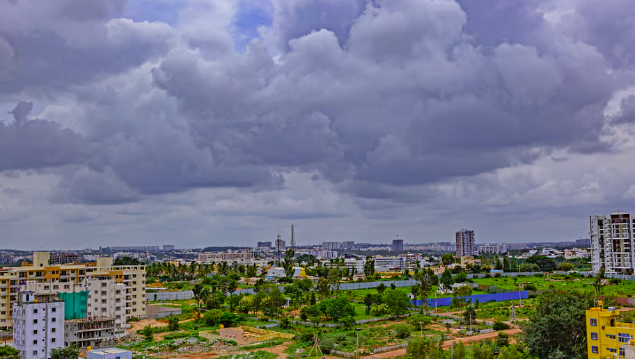
Travel beyond the limits of any Indian city and you will find the dense urban neighbourhoods gradually give way to agricultural fields interspersed with industrial units, warehouses, gated colonies and new infrastructure corridors. These areas have a mix of urban and rural features: Four-lane highways interspersed with agricultural land with mixed habitations.
This shows that while cities expand, they absorb the villages that surround them, creating vast, rapidly changing landscapes that exist between the rural and the urban. These areas are lebelled as peri-urban zone, urban fringe, rurban areas, the rural–urban interface, transitional zones, city outskirts, census towns or urban villages. Neither fully rural nor formally urban, yet they are home to millions of people living on the fringes of cities such as Delhi, Mumbai, Bengaluru, and Chennai, as well as around numerous secondary and Class B cities.
India was 31.1 per cent urban according to the 2011 Census and is estimated to have reached roughly 36-37 per cent by 2024. The report titled Towards Resilient and Prosperous Cities in India stated that with India’s urban population expected to almost double by 2050 to 951 million. Migration is a steady driver — government data suggested close to a fifth of all migration in 2020–21 was rural-to-urban.
But much of this growth is not flowing into existing city limits. It is pooling at the edges. The World Bank estimated that nearly 70 per cent of the urban infrastructure India will need by 2047 does not yet exist, this infrastructure will be built on the margins of the city leading to the peri-urban zones getting urbanised. As of the 2011 Census, India recognised over 3,800 Census Towns.
These areas are administrative anomalies — settlements that are legally classified and governed as rural villages, yet possess distinct urban characteristics (such as population density and a largely non-agricultural workforce). They serve as a primary example of periurban growth. By some estimates, close to 30 per cent of India’s urban population now lives in settlements with no formal urban institution to govern them, and on current trends the census-town count could reach 8,500–9,500 by 2031. However peri-urban areas don’t restrict to the census towns.
Tens of thousands of villages across the country have become functionally peri-urban due to their proximity to economic hubs. These settlements typically fall within a 5-20-kilometre radius of major cities, or lie directly along expanding industrial corridors and metropolitan regions. Because these spaces lack a formal statutory definition, they often fall into a governance vacuum — frequently missing out on both the robust rural development funds and the structured urban planning infrastructure they urgently need. Bengaluru is a good case.
Studies of its periphery have documented around 65 per cent of peri-urban land shifting from agriculture to mixed-use and commercial purposes, concentrated in fringe wards such as Yelahanka, Byatarayanapura and the Kempegowda belt; the NH-7 corridor and metro expansion spurred sprawl while public transport made daily commuting from the outskirts viable. The growth is driven by a familiar pushand-pull.
Inside the city, high land and housing prices, congestion, pollution and overstretched services push people outward; on the fringe, cheaper land, room to build, proximity to jobs and better connectivity pull them in. Highways, ring roads, metro extensions and industrial corridors then act as accelerants, converting farmland into mixed-use sprawl along their length
The Delhi Police on Wednesday sought a three-day extension in the judicial custody of Cockroach Janata Party (CJP)...
Following the deterioration of air quality in Delhi-NCR, the Commission for Air Quality Management (CAQM) on Wednesday implemented...
Prime Minister Narendra Modi will visit Varanasi and Kedarnath on a two-day visit on October 24 and 25....
Stay updated with the latest national, international, Punjab, political, business, crime, weather, sports and entertainment news with The...

The family of 5-year-old Fabiana Cabello in New York City, USA, is in deep shock after her death....

The Delhi High Court on Wednesday posed several questions to Cockroach Janata Party (CJP) leaders Sourav Das and...
Aries: The day will be auspicious...