Last Updated: October 21, 2026
Last Updated: October 21, 2026





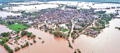
Punjab has faced some of its worst floods in recent years, but this is neither the first time nor likely the last. While extreme rainfall plays its part, a closer look at past incidents and official documents shows that human-made factors and poor management are equally to blame.
Two Decades of Floods
A detailed study of floods between 1990 and 2010 shows that torrential monsoon rains, sudden releases from the Bhakra dam on the Sutlej, weak embankments and poor maintenance of rivers and canals repeatedly caused devastation.Drainage channels often remain clogged because they are not cleaned in time, forcing small streams to overflow and submerge villages. Cracked or neglected embankments make matters worse. In 2005, for instance, floods in Rupnagar district worsened after the Lotan rivulet’s dam developed cracks. Two years later, a railway bridge over the Ganga rivulet in Anandpur Sahib collapsed, breaking a nearby canal embankment and flooding 12 villages. In 2010, Rupnagar, Patiala, Sangrur, Ludhiana and Moga saw heavy losses due to similar breaches.
Farmers too contribute inadvertently by making illegal cuts in canals to divert water, which floods fields and homes. Sudden water releases from Bhakra dam in 1988 and again in 2010 triggered severe flooding. Inadequately designed irrigation projects on the Ghaggar river further obstruct drainage and raise flood risks.
Lessons from 2023
Floods in 2023 exposed more gaps in infrastructure planning. A government guidebook released the following year highlighted how bridges and highways often obstruct natural water flows.
One railway bridge near the Sutlej had a waterway too wide for the river’s lean season. Silt built up over months, narrowing the passage. When heavy rain came, the blocked flow worsened flooding in nearby villages. A similar problem occurred at a road bridge on the Beas, where a narrow waterway and siltation led to embankment breaches during the floods.The guidebook also flagged new elevated highways. Engineers had not studied natural sheet flow—the broad surface runoff during monsoon—before construction. Without proper drainage paths, highways blocked rainwater, creating waterlogging in adjoining areas.
Encroachment and Urbanisation
Rapid and unregulated urbanisation has compounded the problem. Construction along riverbanks obstructs the natural course of water. In Mohali’s Derabassi block, unplanned development was directly linked to local flooding. Planting of eucalyptus trees on riverbeds further restricts drainage.
Temporary structures built by farmers also weaken embankments. Pipe outlets for irrigation or drainage often create weak spots that give way during high water. Similarly, ramps constructed on embankments for access reduce their stability.
Punjab’s Fragile Floodplains
Punjab’s vulnerability is deeply tied to its geography. Most of the state sits on alluvial floodplains shaped by rivers over centuries. These old plains, often elevated above current riverbeds, are interspersed with sand dunes and low-lying patches. About 77 per cent of Punjab’s land falls under such plains.
Three major plains have been identified: the Upper Bari Doab covering much of Amritsar, Tarn Taran and Gurdaspur; the Bist Doab between the Beas and Sutlej; and the Malwa Plain south of the Sutlej, which also includes the floodplains of the Ravi, Beas, Sutlej and Ghaggar. Together, these areas cover nearly the entire state.The soil here is layered and constantly reshaped by erosion and deposition. This makes it less stable and more prone to flooding. Adding to this are paleo channels—the remnants of old river courses long blocked by silt. These channels lie in depressions that naturally collect water during floods, worsening inundation.
A Pattern of Neglect
The recurring pattern across decades is clear. Heavy rainfall may trigger floods, but the damage is magnified by poor river and canal management, silted waterways, neglected embankments, unplanned construction and encroachments. Even as Punjab modernises its infrastructure, failure to account for natural water flows has introduced new risks.Unless embankments are maintained, drainage cleared, and urbanisation checked along rivers, the state will remain highly vulnerable. Punjab’s geography makes it prone to floods, but it is governance and planning failures that turn heavy rains into disasters.
We are very proud that at present India is the number one country in the world by surpassing...

Every investor wants the wealth-creating power of equity and the reassuring stability of debt. Balanced Advantage Funds attempt...

Tourism is a major source of government revenue in our country. There are different types of tourism. Scenic...

Good Evening Viewers! Catch up on the day's biggest stories with The Savera Times Evening Bulletin. Get the...

Congress leaders continued their protest outside the Jaipur Police Commissionerate on Tuesday, demanding the registration of a zero...

On the auspicious occasion of Vijayadashami, Prime Minister Narendra Modi on Tuesday called on the countrymen to unite...

Aries: The day will be auspicious...